


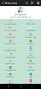

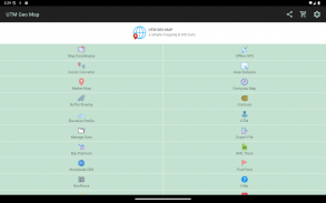


UTM Geo Map

Description of UTM Geo Map
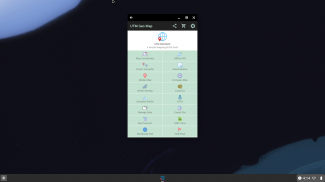
UTM Geo Map is a versatile application designed for land surveying, topography, bathymetry, and GIS (Geographic Information Systems) analysis. Available for the Android platform, this app allows users to efficiently manage and analyze geographic data, making it a valuable tool for professionals in various fields, including civil engineering, geology, and geodesy. Users can download UTM Geo Map to access a range of features that support spatial analysis and mapping.
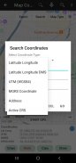
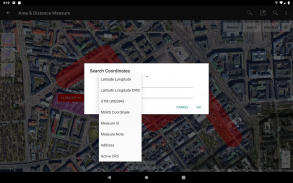
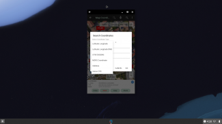
One of the primary functionalities of UTM Geo Map is the ability to obtain precise coordinates in real time. Users can capture latitude and longitude, UTM, and MGRS coordinates, which can be registered with additional information such as time, elevation, and notes. This feature is particularly useful for fieldwork where accurate location data is essential.
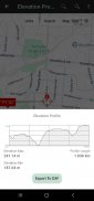
The Elevation Profile module allows users to create simple cross-sectional and long-sectional elevation profiles using height data. This module supports both metric and imperial units, making it adaptable to different regional preferences. Users can generate profiles from multiple points, and with the premium version, they can create profiles based on specific routes.
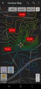
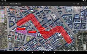
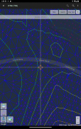
Generating contours is another significant feature of UTM Geo Map. This module enables users to create contour lines based on a specified number of lines, desired elevation, or contour intervals. The contours provide critical insights into the terrain's shape and elevation changes, which are essential in surveying and land use planning. This premium feature requires an internet connection for optimal performance.
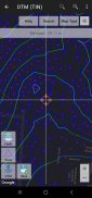
The Digital Terrain Model (DTM) module enhances the app's capabilities by allowing users to generate TIN (Triangulated Irregular Network) or GRID surfaces from elevation data. This module is designed for calculating cut and fill volumes, refining TINs, and performing grid interpolation. Users can also generate dynamic elevation profiles that reflect real-time changes in the terrain.
For those who need to work offline, the Offline GPS module functions as a handheld GPS device. It provides users with latitude and longitude coordinates, elevation data (including ellipsoid and mean sea level elevation), and satellite information without an internet connection. This feature is particularly useful in remote areas where connectivity may be limited. Users can store an unlimited number of coordinates along with notes, labels, and photos, which can be exported in various formats, including CSV, KML, DXF, and GPX.
The app also includes a Coordinate Converter, which allows users to manually convert coordinates between latitude/longitude and UTM/MGRS formats. This tool can also convert addresses into coordinates through geocoding, although this feature requires an internet connection. The converter supports batch operations, making it efficient for users who need to process multiple coordinates at once.
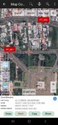
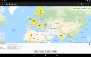
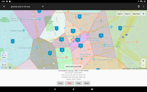
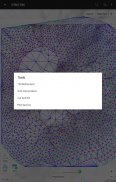
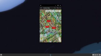
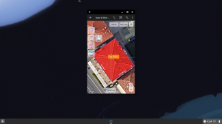
Map Coordinates functionality enables users to obtain real-time geographic data and register points complete with coordinate details. This module supports dynamic display of TINs, Voronoi diagrams, and buffers based on existing points. It provides an intuitive interface for visualizing spatial relationships and analyzing geographic data.
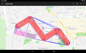
Marker Map offers enhanced geometric analysis capabilities. Users can display dynamic and variable buffers and perform geometric calculations using a combination of point data, lines, and polygons. This module also allows for the export of geometrical data to KML or DXF formats, facilitating compatibility with other devices or software.
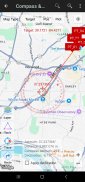
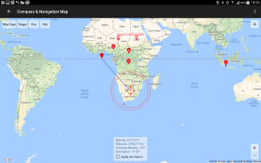
The Compass Map module assists users in navigation by providing a map alongside a compass with magnetic declination. This feature allows users to measure azimuth angles and determine distances and directions, which can be valuable in outdoor activities or field surveys.
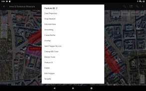
Buffering and overlay capabilities are integrated into the app, enabling users to perform various GIS operations. This includes options for union, intersection, difference, and symmetrical difference, allowing for complex spatial analyses tailored to user needs.
UTM Geo Map is a practical solution for professionals and enthusiasts engaged in geographic data management. Its comprehensive set of tools supports tasks ranging from simple coordinate acquisition to complex terrain modeling and spatial analysis. The app's versatility makes it suitable for a wide range of applications in land surveying, civil engineering, and environmental studies.
With its user-friendly interface and robust features, those interested in geographic information can find UTM Geo Map to be an efficient tool for their needs. The ability to download UTM Geo Map provides access to these functionalities, enhancing productivity in geographic studies and analyses.
For more information, visit the official website: https://www.utmgeomap.com and check the quick guide at https://www.utmgeomap.com/utmgeomapquickstart.pdf. You can also explore tutorials and updates on their YouTube channel: https://www.youtube.com/channel/UCspxQ5nQiqRD88g_-6GcCqw.
UTM Geo Map - Version 4.2.95
(14-05-2025)
UTM Geo Map - APK Information
APK Version: 4.2.95Package: info.yogantara.utmgeomapLatest Version of UTM Geo Map
Other versions


Apps in the same category


